|
Hiking
in Rock Creek Park Rock Creek Conservancy Biking
in Rock Creek Park (Bike Washington) Back
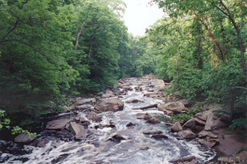
to Washington, DC page Rock Creek Park Visitors to Washington know the Mall as a welcome swath of green among the city's monuments and museums. But hikers and bikers can head from the Mall into Rock Creek Park, a refreshing escape to a wilderness that goes north past the National Zoo and into Maryland. Created in 1890, Rock Creek Park is one of the largest forested urban parks in the United States, containing a wide variety of natural, historical, and recreational features in the midst of Washington, DC. It is nearly a mile wide in some places and is laced with an extensive system of trails and paths. Certain sections of Beach Drive, which parallels the creek, are closed to vehicles on weekends and holidays. Photos on these pages were taken along one of these sections, from Broad Branch north to Military Road.
Eons of Park history What put the rocks in Rock Creek Park? The jumbled mass of rocks and ledges along and in Rock Creek is what is left of an ancient mountain range. The greatest abundance of boulders is located in a roughly one-mile stretch between Broad Branch and Military Roads, as this is the "fall line" separating two different geologic provinces—the Piedmont Plateau and the Coastal Plain. The
process began eons ago, when the ancient mountains slowly decayed
until only their roots remained. Crustal movements caused this
relatively level surface to tilt, and the eastern part of it
was submerged. A new cycle of erosion set in, and the clay,
sand, and gravel carried from the higher western region were
deposited on the submerged surface. These sediments built up
to form the Coastal Plain, extending from Washington, DC to
the Atlantic Ocean. The higher surface west of Washington is
called the Piedmont Plateau. >> Concise explanation of the geology of Washington, DC >> Extensive information about the geology of Washington, DC can be found on Northern Virginia Community College Geology Instructor Callan Bentley's website.
>> The Native Woodland Peoples of the Rock Creek Valley [National Park Service PDF]
The most famous mill owner was Isaac Peirce (also spelled Pearce or Pierce), who in 1794 bought a mill and 150 acres along the creek where corn and wheat were ground into flour. By 1800 he controlled an estate stretching from today's National Zoo to Chevy Chase. In 1829, Isaac and his stonemason son Abner Peirce rebuilt Peirce Mill, which is today the only surviving mill along the creek. Their spring house, built in 1801, still stands in the middle of Tilden Street. Rock Creek Gallery occupies Peirce's carriage house. The family distillery is now a private home across the street. Peirce Mill prospered until steam power undercut the water mills in the 1880s. The main shaft of the mill broke in 1897. [More on restoring and visiting the mill: Friends of Peirce Mill.]
Beach Drive was named after Lansing Beach, who directed its original construction. The section between Military Road and the site of Argyle Mill was inaugurated in 1899. Boulder Bridge (pictured at left) was finished in 1902. In
1904 the Peirce Mill waterfall was constructed to ornament what
had become a popular picnic area and meeting place. By 1905
Peirce Mill was in use as a tea house. African-American Hattie
L. Sewell took over the concession in 1920, but her lease was
not renewed after racially motivated complaints. The Girl Also in Rock Creek Park is the National Zoo, administered by the Smithsonian Institution. It features natural environments for many of its 2,000 animals. The park also has remnants of forts that protected the city during the Civil War, including Fort Stevens, the site of the only battle within the District of Columbia.
Crestwood: 300 Acres, 300 Years by David Swerdloff is the story of a Northwest Washington, D.C. neighborhood and its uncommon connections with the history of the Nation's Capital. Using more than 200 photographs, maps, documents and news articles, the 132-page book explores a community that has had recognizable borders ever since the first survey of an estate called Argyle Cowall and Lorn in 1720. We meet a wide variety of people who traveled to or through the area we now call Crestwood--including Native American tool makers, Civil War soldiers, horse racing fans, city dwellers looking for an outing "in the country" and U.S. presidents from Abraham Lincoln to Teddy Roosevelt. The book uncovers links between Crestwood and St. Elizabeths hospital, the building of the U.S. Capitol, Russian diplomacy, the escape attempt by D.C. slaves aboard The Pearl, the first mass protest march on Washington and four Supreme Court decisions. Even readers who may not be able to locate Crestwood on a map will gain insights into how D.C. developed beyond its central core and learn to recognize historical clues hidden in plain sight in a community's streets, structures and landscapes. All proceeds benefit the Crestwood Citizens Association. Order from Amazon or from Politics and Prose
|

 British
Ambassador Lord James Bryce described the park this way in 1913:
British
Ambassador Lord James Bryce described the park this way in 1913:
 Records
of early European settlers include the writings of Captain John
Smith, which suggest he may have ventured by Rock Creek during
the early 1600s. A trading post was founded at the mouth of
the creek in 1703. As Georgetown and Alexandria developed into
ports, ships could sail up Rock Creek as far as P Street. Beginning in 1760, mills drew power from the creek to serve farmers
in the valley. Eventually 19 grist and bone mills, which also milled lumber, operated along
the banks of the creek, and stone was removed from 17 quarries
for numerous building projects in the area.
Records
of early European settlers include the writings of Captain John
Smith, which suggest he may have ventured by Rock Creek during
the early 1600s. A trading post was founded at the mouth of
the creek in 1703. As Georgetown and Alexandria developed into
ports, ships could sail up Rock Creek as far as P Street. Beginning in 1760, mills drew power from the creek to serve farmers
in the valley. Eventually 19 grist and bone mills, which also milled lumber, operated along
the banks of the creek, and stone was removed from 17 quarries
for numerous building projects in the area.  Argyle
Mill was located on what today is a clearing on the west side
of Beach Drive just below Boulder Bridge. Built by the Peirces, it was owned by Thomas
Blagden (1815-1870), whose father George was superintendent
of the stone work used in constructing the Capitol. Both the
mill and the estate were named Argyle after a region of western Scotland.
The mill was severely damaged by flooding in 1889. The ruins
were removed in 1899 during the initial construction of Beach
Drive. One of the old bridge abutments leading to the mill survives
on the east bank of the creek.
Argyle
Mill was located on what today is a clearing on the west side
of Beach Drive just below Boulder Bridge. Built by the Peirces, it was owned by Thomas
Blagden (1815-1870), whose father George was superintendent
of the stone work used in constructing the Capitol. Both the
mill and the estate were named Argyle after a region of western Scotland.
The mill was severely damaged by flooding in 1889. The ruins
were removed in 1899 during the initial construction of Beach
Drive. One of the old bridge abutments leading to the mill survives
on the east bank of the creek.  Scouts
ran the tea house for a while, followed by a charitable group
within the War Department. The last tea was poured in 1934 when
the first restoration of the mill was ordered. During the 1930s
the Civilian Conservation Corps was active in the park, building
the stone house now used by the Park Police.
Scouts
ran the tea house for a while, followed by a charitable group
within the War Department. The last tea was poured in 1934 when
the first restoration of the mill was ordered. During the 1930s
the Civilian Conservation Corps was active in the park, building
the stone house now used by the Park Police. 